
Geographic Information System (GIS) is one of the best tools for managing geographic information. It is estimated that about 85% of the information managed by cities and counties is geographically referenced (i.e., located on the Earth) in some way, such as the location of a building shown on a map. Examples of geographic information are addresses, parcels, school district boundaries, a road network, land use patterns, buildings, and utility locations.
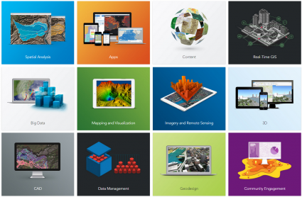
PGT offers a complete line of GIS data development and Deployment services. GIS feature classes and datasets can be constructed according to client specifications, or GIS Group can provide a comprehensive set of attributes that follow industry standards. We offer the following Services with a professional team of GIS Engineers, Remote Sensing Data Scientists and Developers.

- Base and thematic mapping
- Data collection, conversion and automation
- Geo-Database design and deployment
- Spatial Analysis
- Geo-visualization (web and mobile devices)
- Big data analytics
- Geo-AI applications
- GIS Applications development
- Geodetic network design
- GNSS/GNSS-R applications
- Designing GIS Dashboards and Web Applications
- ArcGIS Server and Portal Installation and Integration
- GIS SDE Environment Development and Integration
- Real-time GIS Surveying and Mapping
- 3D Data Mapping
- BIM Modeling

- Land-use / Land cover mapping
- Image classification
- Feature extraction and edge detection
- Data fusion
- 3D terrain modeling
- Environmental monitoring
- Satellite Image Analysis
- Data Extraction from Satellite Imagery
- Time Series data mapping
- Topographic surveys
- Boundary and cadastral Surveys
- Construction staking and layout
- As-built surveys & Verification
- 3D laser scanning and Modelling
- Hydrographic Surveying
ARCHITECTURE & ENGINEERING SERVICES – (BIM/3D)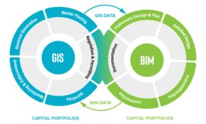
- Design services
- Site planning and development
- Construction project management
- Quantity surveying and cost estimation
- BIM Modelling
- Revit Model Design
- LOD 200, 400, 500 Modelling
- Infrastructure Design Services
- BIM to GIS Conversion
- BIM – GIS Integration

- Web Development
- Corporate Graphic Designing
- Mobile App Development
- Customized Web Application Development
GIS Machine Learning and Artificial Intelligence
- Spatial Data Analysis and Pattern Recognition: Leveraging AI algorithms to analyze spatial data and identify trends, patterns, and anomalies.
- Predictive Modeling: Using machine learning models to predict future
spatial phenomena such as urban growth, environmental changes, and disaster risk areas. - Land Use and Land Cover Classification: Classifying land use and land cover from satellite imagery using AI and machine learning techniques to support urban planning and resource management.
- Environmental Monitoring: Implementing AI to monitor environmental changes, track wildlife movements, and assess the impact of human activities on ecosystems.
- Geospatial Data Integration and Visualization: Combining multiple geospatial data sources and creating interactive visualizations to provide comprehensive insights.
- Route Optimization and Navigation: Developing intelligent navigation systems that optimize routes for logistics, transportation, and emergency response based on real-time data and AI analysis.
- Smart City Solutions: Utilizing AI to enhance urban infrastructure, manage traffic, optimize energy usage, and improve public services.
- Disaster Response and Management: Applying machine learning to predict natural disasters, assess damage, and coordinate emergency response efforts efficiently.
- Geospatial Intelligence for Security and Defense: Analyzing spatial data to provide actionable intelligence for security, surveillance, and defense operations.
- Custom AI Solutions for GIS: Developing tailored AI models and algorithms to address specific geospatial challenges and improve decision-making processes.
These services can help organizations harness the power of AI and GIS to gain valuable insights and make informed decisions. If you’d like more details on any of these services, feel free to ask!